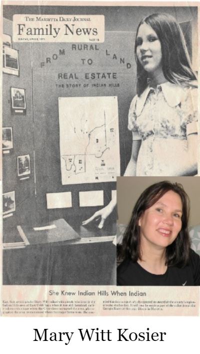
 The following article is adapted from a history project done in 1973 by Mary Witt, while living on Sentry Crossing and attending the 7th Grade at East Cobb Middle School. Mary won the Cities and Towns Award of ‘the Georgia Municipal Association at the Cobb Regional Science Fair with her historical essay and accompanying pictorial display. Mary is now married --- living with her husband and son in Jupiter, FL. Her folks – Doug and Virginia - live in Roswell.
FROM INDIAN LANDS TO INDIAN HILLS --- COBB PIONEER FARMS NOW COUNTRY CLUB COMMUNITY By Mary Witt
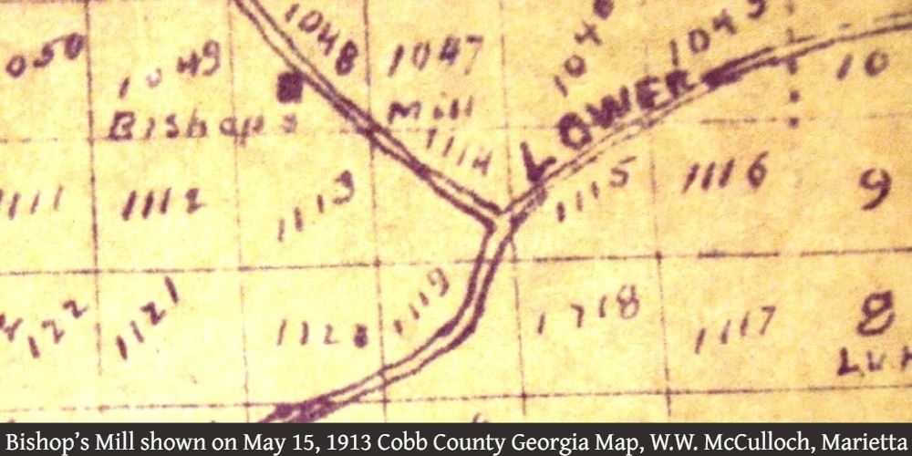
Originally it was called Bishop’s Mill Road. In the early 1900’s it became Gray Road, and still shows by that name on some maps. Then in 1969 it became Indian Hills Parkway.
No trace of Bishop’s Mill remains; its site is now the 11th green [Seminole #2] of the Indian Hills golf course. At Sentry Crossing and the Parkway, the Bishop family cemetery is still neatly kept. The huge oak [cut down July 2009] along Indian Hills Parkway marks the place where stood the buildings of the Preston Farm which became the Gray Farm, on part of the Bishop land. It was also the site of the farmhouse of Clarence C. Bishop, grandson of the pioneer founders of Bishop Farm. Beside Fair-green Lane is the spring that once supplied the Bishop farmhouse, and near the golf driving range there once were barns and a blacksmith shop. Except in the memories of longtime residents, few details remain of the rural pioneer settlement of this area.
In the 1830s, the Cherokee Nation owned Indian Hills. Indian families lived along the spring fed streams, and a Cherokee burial ground was located on the hill enclosed by Fairgreen Drive. But Georgia’s settlers had reached the Chattahoochee River, and discovery of gold in the mountains to the north created irresistible pressure on the Indian lands and treaty rights.
In 1832, Georgia took control of the Cherokee lands up to the Tennessee border and organized ten counties, including Cobb. It began a survey, and offered tracts of land by lottery for settlement. Some 18,000 tracts of 160 acres, of which 342 are in Northwest Cobb around Acworth and Kennesaw, went by lottery. Also, a “gold lottery” offered 38,000 tracts of 40 acres each, of which 4,360 covered most of Cobb County.
No gold was found in these Cobb “gold lots”, but settlement began quickly and by 1845 all of the land lots had been taken up. Many of the people who drew lots sold their 40 acres for $10 or $20, or swapped them for a horse.
These lots were combined in the early farms. Although the Cherokee had prior treaty rights by which an Indian family could settle on 640 acres, the pressure for white settlement caused the U.S. Government to arrange for removal of the last Indian families to new lands west of the Mississippi by the end of 1838.
General destruction of county and family records in 1864 makes it difficult to trace the history of the pioneer settlers and their farms. There were Bishops among the earliest arrivals. Abner and Stephen Bishop drew land in the lottery. Ephraim Bishop of Kennesaw went with the Georgia Militia to Mexico in 1846. His daughter, Mildred Ann, in 1848 married Robert McAlpin Goodman who founded the Marietta Journal. William L. Bishop, born in 1823, developed the Bishop Farm.
Bishop’s farm once covered a more extensive area, but later retained the present Clubhouse area and extended across Fairgreen, Summit, and Hillwood Drives. To the north and west became the Gray Farm, including the present “front nine” [Choctaw]. To the east, in the Fairfield Drive area was the Bill Dickerson Farm, with its buildings near the present 16th green [Seminole #7]. In the Ridgewater area was the Haney Farm. Indian Hills Trail now passes through the former Clark Farm. Children from these farms attended the one-room log school at what is now Timberwood Terrace. Across Sope Creek, now Indian Hills Court, was a factory that made wooden churns and barrels. On a Union Army map, drawn during the 1864 campaign in Georgia, the western part of Indian Hills, where the “new nine” [Cherokee] straddles Sope Creek, was shown as the Gober Farm
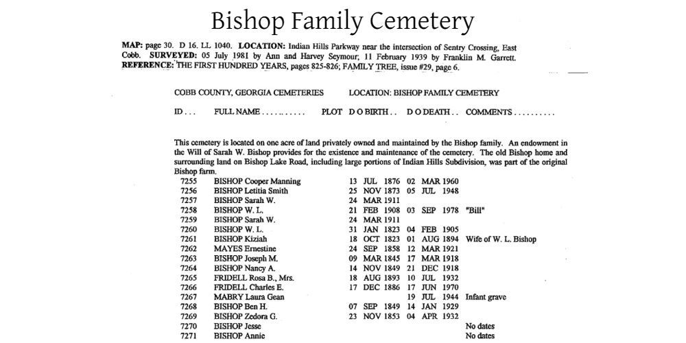
The old cemeteries give most of the clues to the past. William L. Bishop (1823-1905) is buried among the 18 graves in the family cemetery beside Indian Hills Parkway. The oldest headstone is that of his wife, Kiziah, (1823-1894). Two graves have no dates and three are unmarked. Also buried there are William’s sons, their wives, and descen- dants. Joseph M. Bishop (1845-1918) served in the Georgia Militia in the Civil War, as did Ben H. Bishop (1849-1929) who was Second Lieutenant of the Roswell Guards and was wounded at Manassas. The latest grave is that of Charles E. Fridell (1886-1970) beside that of his wife, Rosa Bishop Fridell (1893-1932). Beside Upper Roswell Road, at the end of Fielding Way, is the Tritt family cemetery. William Tritt (1820-1906) and his wife, Emily (1823-1891) established a pioneer farm to the north. A descendant, Odessa Tritt Lassiter (1880-1948) lived in a log house built by her husband. It stood between Sentry Crossing and High Green Place, and was owned and occupied by Mrs. Iris Ward [until a fire destroyed the home and caused her death in the late 1980s].
In early July 1864, while Sherman’s forces were pushing Johnston’s troops back from Kennesaw Mountain, Union Cavalry ranged through this area. They burned the paper mill on Sope Creek near the present Atlanta Country Club and later burned the cotton and woolen mills at Roswell. General John Schofield sent his corps across the Chattahoochee at the mouth of Sope Creek, in a flanking attack to begin the Battle of Atlanta. The ruins of the paper mill and surrounding scenic area became a popular place for picnics. Their preservation caused a major delay in construction of the Sope Creek sewer line, which eventually had to be tunneled through the rock. This, in turn, caused some delay in construction of homes in Indian Hills.
Sope Creek, winding through the homes and fairways of present-day Indian Hills, is a reminder of the area’s past. In her book, “The First Hundred Years”, published in 1935, Sarah Temple describes the origin of its name: “Out on Roswell Road, about halfway between Marietta and Roswell, the new settlers could see the cabins of several Indian families. One of these cabins was occupied by Old Sope who had lived there for so long that a creek and a branch were named for him. Old Sope was a kindly person and little boys liked him so much that they ran away from home to visit him. He would tell them stories and teach them Cherokee words. Although a full-blooded Cherokee, Old Sope managed to remain in Cobb after the Indians emigrated, and such were his relations with his youthful white neighbors that he has left a pleasant memory to this day.
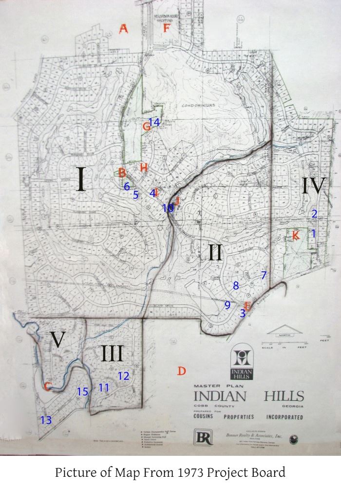
Map Information from 1973 Project Board -Mary Witt
The farms:
I. Gray farm
II. Bishop farm
III. Clark farm
IV. Dickerson farm
V. Haney farm
The following landmarks were originally shown along with the photos on facing page:
A. East Side Elementary School
B. Bishop family Cemetery
C. Sope Creek
D. Home of woman who was first interviewed (forgot name, she led me to Roger Thompson)
E. Indian Hills subdivision entrance sign in 1973
F. Zoning notice for undeveloped land (caption : What is the future of this land?)
G. Iris Ward’s home (formerly Lassiter home) H. Civil war trench wall (on Sentry Crossing)
I. Trees around site of old Gray Barns (with new home) J. Bishop Creek (by the golf course 11th hole)
K. Roger Thompson’s home (source of the information on the map)
Other points of interest indicated on the map from the interview of Roger Thompson [Mary interviewed him in 1973 as a part of her project]:
1. Old Bill Dickerson House
2. Old Bill Dickerson Tenant House
3. Old Clarance Bishop House
4. Gray Barns (photo of trees at location)
5. Preston Farmhouse and House
6. Bishop Cemetery (also in photo)
7. Indian Mound
8. Bishop Spring
9. Blacksmith shop
10. Bishop Mill
11. Dr. Oliver’s House
12. Old Schoolhouse
13. Newt Haney House
14. Lassiter House (photo -- later, Iris (Mrs. Harvey) Ward Home)
15. Churn & Barrel Factory
